Heritage · Landmark
Angkor Wat: History, Attractions & Visitor Guide
Angkor Wat is the largest religious monument on earth, 162 hectares raised by Suryavarman II in the twelfth century as a Hindu temple and later Buddhist.Written to last.
By Confinity Heritage Editorial · Updated 2026-07-20 · 7-minute readQuiet tools, kept out of the way.
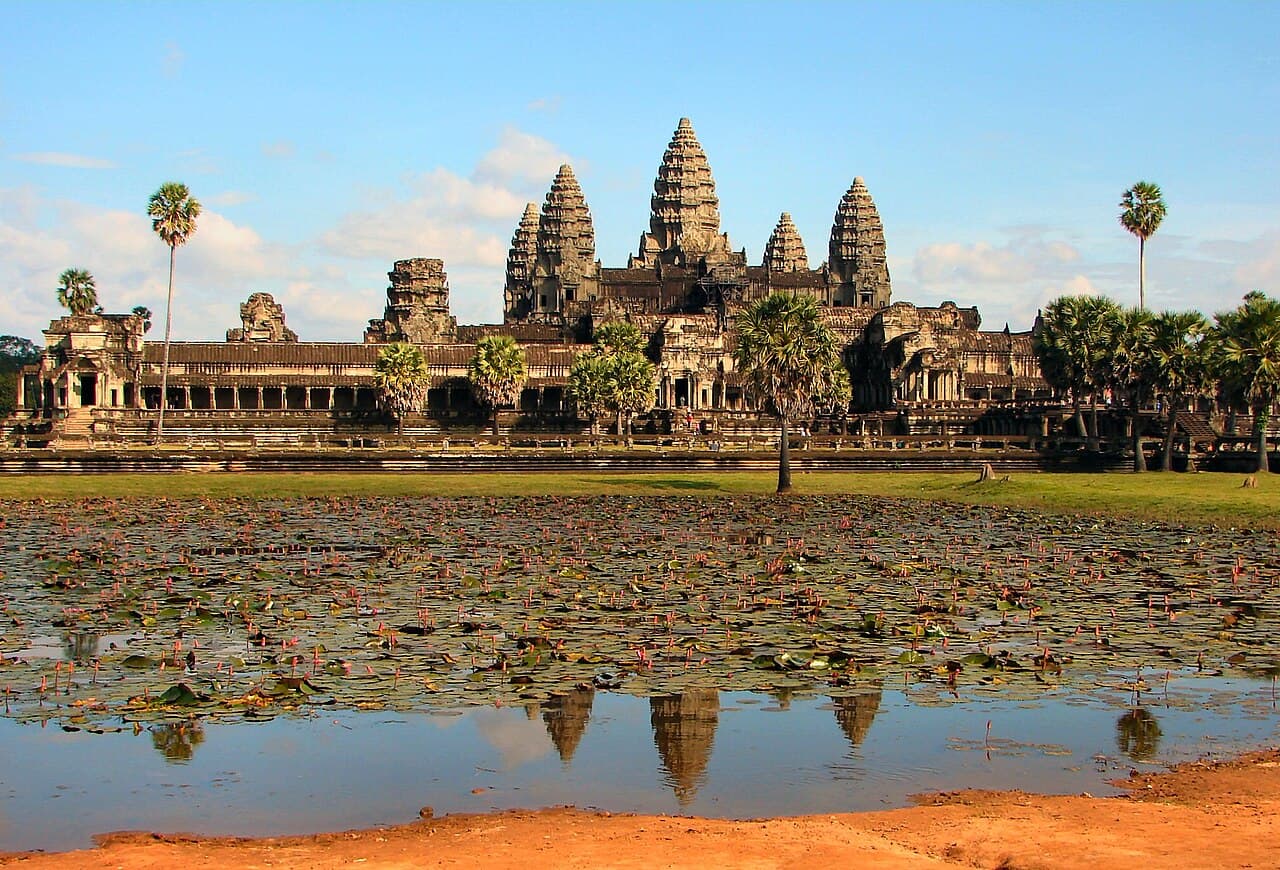
Angkor Wat is a temple complex in northwestern Cambodia and the largest religious monument in the world, covering about 162.6 hectares (402 acres) near the town of Siem Reap. King Suryavarman II built it in the first half of the 12th century as a Hindu state temple dedicated to the god Vishnu, and by the end of the 13th century it had gradually passed into Theravada Buddhist use, which continues today. Its five lotus-bud towers, wide moat, and long galleries of carved stone have made it the defining symbol of Cambodia, and a depiction of the temple has appeared on the national flag since the 19th century. In 1992 UNESCO inscribed the wider Angkor site on the World Heritage List.
Angkor, from the Sanskrit nagara meaning "city," was the capital region of the Khmer Empire, which ruled much of mainland Southeast Asia between the 9th and 15th centuries. Successive Khmer kings built a chain of capitals and state temples across the plain north of the Tonle Sap lake, supported by an extensive network of reservoirs and canals that watered rice fields and sustained a large population. Angkor Wat belongs to the height of that building tradition, and it is the best preserved of the hundreds of temples that survive in the area.
Suryavarman II reigned from about 1113 to 1150 and commissioned Angkor Wat as his state temple and, most scholars believe, his eventual funerary monument. Work is thought to have begun in the first decades of his reign and to have been largely finished by the time of his death around 1150, an unusually short span for a monument of this scale. The name Angkor Wat pairs the Khmer word for the region, angkor, with wat, meaning temple or monastery, and is usually translated as "Temple City" or "City of Temples." That name dates from later centuries; the temple's original name is not securely known, though an inscription refers to it as Vrah Vishnulok, the "sacred dwelling of Vishnu."
Unusually for a major Khmer temple, Angkor Wat faces west rather than east. West is the direction associated both with the god Vishnu and with death, which supports the reading of the building as a shrine and a royal mausoleum at once. Religious life at the site changed over the following century. After the Cham sacked Angkor in 1177 and the Buddhist king Jayavarman VII rebuilt the empire from his new capital at Angkor Thom, Buddhism spread widely. From the late 13th century onward Angkor Wat gradually converted to Theravada Buddhist worship, and Buddha images were installed among the earlier Hindu carvings. Unlike many Angkorian temples, it was never fully abandoned. Buddhist monks kept a presence there through the centuries after the Khmer court moved south toward Phnom Penh in the 1400s, which is one reason the fabric of the building survived so well.
Angkor Wat is a "temple-mountain," a form the Khmer used to model the Hindu cosmos in stone. Its rising tiers represent Mount Meru, the mythical mountain at the center of the universe and home of the gods, while the enclosing wall and broad moat stand for the mountain ranges and the ocean that ring the world. Five towers crown the temple in a quincunx, one at the center and four at the corners of the uppermost level, echoing the five peaks of Meru. The central tower rises about 65 metres (213 feet) above the ground.
 The plan only resolves from above: a temple-mountain at the centre of a rectangular moat nearly a mile across. Photograph by Charles J Sharp, CC BY 2.5, via Wikimedia Commons.
A rectangular moat roughly 190 metres wide surrounds the complex, its outer perimeter running more than 5 kilometres and enclosing a rectangle of about 1.5 by 1.3 kilometres. A sandstone causeway about 350 metres long crosses the moat from the western entrance, lined with balustrades carved as multi-headed naga serpents. Beyond it, a series of concentric galleries and gopura gateways step inward and upward toward the innermost sanctuary, the Bakan, which sits on the highest of three rectangular tiers. Two small buildings usually called libraries stand within the enclosure, and a cruciform gallery once known as the Hall of a Thousand Buddhas connects the outer courtyards to the higher levels. Two ponds flank the causeway inside the outer wall, and the northern one is the vantage point from which visitors photograph the towers mirrored in the water at dawn. The steep stairways to the upper tier, once climbed directly, are now fitted with a wooden staircase to protect both the worn stone and those making the ascent.
The outer gallery, measuring roughly 187 by 215 metres, carries one of the longest continuous bas-reliefs in the world along the inner face of its walls. Each side tells a different set of stories drawn from Hindu myth and Khmer history. The western wall shows the Battle of Lanka from the Ramayana and the Battle of Kurukshetra from the Mahabharata. The southern wall depicts a historical procession of Suryavarman II with his army, together with images of 37 heavens and 32 hells presided over by Yama, judge of the dead. The eastern wall holds the celebrated Churning of the Sea of Milk, in which 92 asuras and 88 devas haul on the serpent Vasuki to draw the elixir of immortality from the ocean. Further panels on the north and east record the victories of the god Krishna. Some scholars note that the reliefs read most naturally when walked counter-clockwise, the direction used in Hindu funeral rites, which again points to the temple's funerary role.
Celestial figures cover the stone throughout the complex. Researchers have documented more than 1,796 depictions of devatas, female divinities shown standing in niches and doorways, alongside many smaller apsaras, dancing figures around 30 to 40 centimetres tall carved in shallow relief. No two are quite alike in dress, jewellery, or hairstyle.
The temple was built mainly from sandstone quarried at Phnom Kulen, a plateau about 40 kilometres to the northeast, with laterite used for foundations, hidden cores, and outer walls. The total runs to several million blocks, some weighing more than a tonne, which were floated to the site along rivers and canals. The finely dressed sandstone was laid without mortar, the blocks fitted so closely that many joints are hard to see, and held in place by iron cramps and the weight of the stone above. The Khmer roofed their galleries with corbelled vaults rather than true arches, a technique that limited the width of interior spaces but has kept much of the structure standing for more than eight centuries.
For its first century and a half Angkor Wat was a center of Vaishnavite Hinduism, its rituals focused on Vishnu as protector of the king and the ordered cosmos. The later shift to Theravada Buddhism did not erase that heritage. The complex remains an active place of worship today, where monks live and where pilgrims and visitors leave offerings, and both traditions are visible in its shrines, its Buddha images, and its surviving Hindu carvings. As the largest religious structure ever built, it also functions as a lasting record of Khmer belief and craftsmanship.
Angkor Wat is the enduring emblem of the Cambodian nation. A representation of the temple has appeared on Cambodian flags since the 1860s, and the modern red-and-blue flag, adopted in 1948 and restored in 1993, places a white three-towered image of Angkor Wat at its center. Cambodia is the only country whose national flag shows a building. The temple's silhouette also appears on Cambodian banknotes and on the labels of the country's best-known beer, and it remains a focus of national pride and continuity after the wars and the Khmer Rouge period of the late 20th century.
The site anchors Cambodian religious and cultural life. Buddhist festivals bring worshippers to its galleries, and the temple features in national ceremonies and in the imagery of Khmer classical dance, whose apsara dancers echo the figures carved on the walls. For Cambodians and visitors alike, sunrise over the five towers, mirrored in the western reflecting pools, has become one of the most recognisable images in Asia.
Angkor Wat was never truly lost. Khmer Buddhists kept it in use, and it drew occasional foreign travellers, among them the Portuguese friar António da Madalena, who described the ruins in 1586. It entered wide Western awareness only in the mid-19th century, above all through the French naturalist Henri Mouhot, whose journals and drawings, published after his death in the early 1860s, brought the temples to a large European audience. Mouhot did not discover Angkor, and later writers have corrected the romantic story that the site was unknown before he arrived.
Systematic conservation began in 1908, when the École française d'Extrême-Orient set up the Conservation d'Angkor to clear vegetation and stabilise the monuments, often using anastylosis, the careful dismantling and rebuilding of collapsed sections with their original stones. Cambodia's civil war and the Khmer Rouge period interrupted this work from the 1970s and left the temples exposed to looting and landmines. When UNESCO inscribed Angkor on the World Heritage List in December 1992, under all four of its cultural criteria, it placed the property at the same time on the List of World Heritage in Danger because of pillaging, illicit excavation, and unstable conditions. An International Coordinating Committee for Angkor, known as ICC-Angkor and co-chaired by France and Japan, was created in 1993 to guide teams from many countries, including India, Germany, China, the United States, and Cambodia itself.
That combined effort of restoration and anti-looting work led UNESCO to remove Angkor from the danger list in 2004. The APSARA National Authority now manages the Angkor Archaeological Park and balances conservation against the pressures of mass tourism, groundwater extraction, and a changing climate. Airborne lidar surveys carried out since 2012 have mapped a dense urban landscape hidden beneath the forest around the temples, confirming that Greater Angkor was among the most extensive settlements of the preindustrial world, home to a population in the hundreds of thousands.
Angkor Wat stands within the Angkor Archaeological Park, about 6 kilometres north of Siem Reap in northwestern Cambodia, near latitude 13.41 north and longitude 103.87 east. The park spreads over some 400 square kilometres and holds hundreds of temples. Angkor Wat is the most visited, but many travellers combine it with the Bayon, the temple at the center of the walled city of Angkor Thom whose towers carry giant carved faces, and with Ta Prohm, left partly wrapped in the roots of silk-cotton and strangler fig trees. A common one-day route takes in Angkor Wat at sunrise, Angkor Thom and the Bayon through the morning, and Ta Prohm in the afternoon, with sunset from the hilltop temple of Phnom Bakheng. Those with more time often add Banteay Srei, a small 10th-century temple of pink sandstone about 25 kilometres from the main group, prized for the crispness of its carving. Siem Reap has an international airport and a wide range of hotels and guesthouses, and serves as the base for most visits.
Entry to the park requires an Angkor Pass, sold by the state operator Angkor Enterprise. Passes are available for one day, three days, or seven days, with the multi-day options usable across a longer window rather than on consecutive days. Prices and opening hours change from time to time, so it is worth checking the official ticketing site before travelling. The temple usually opens before dawn so that visitors can watch the sun rise behind its towers, a popular but crowded moment; the wider park stays open through the afternoon for sunset views from higher ground.
Angkor Wat is a working religious site, and visitors are asked to respect it as one. Modest dress is expected, with shoulders and knees covered, and quiet behaviour near shrines and monks. The park's code of conduct restricts climbing on fragile carvings and closes certain upper terraces to protect both the stone and the safety of visitors. The dry season, roughly November to March, brings the coolest and most comfortable weather and the largest crowds. The wet season, from about May to October, is hotter and more humid but greener, with fuller moats and fewer people. A guide, whether a licensed local guide or a well-researched book, adds a great deal, since much of what makes Angkor Wat remarkable lies in the detail of its carvings and the meaning behind its plan.
The plan only resolves from above: a temple-mountain at the centre of a rectangular moat nearly a mile across. Photograph by Charles J Sharp, CC BY 2.5, via Wikimedia Commons.
A rectangular moat roughly 190 metres wide surrounds the complex, its outer perimeter running more than 5 kilometres and enclosing a rectangle of about 1.5 by 1.3 kilometres. A sandstone causeway about 350 metres long crosses the moat from the western entrance, lined with balustrades carved as multi-headed naga serpents. Beyond it, a series of concentric galleries and gopura gateways step inward and upward toward the innermost sanctuary, the Bakan, which sits on the highest of three rectangular tiers. Two small buildings usually called libraries stand within the enclosure, and a cruciform gallery once known as the Hall of a Thousand Buddhas connects the outer courtyards to the higher levels. Two ponds flank the causeway inside the outer wall, and the northern one is the vantage point from which visitors photograph the towers mirrored in the water at dawn. The steep stairways to the upper tier, once climbed directly, are now fitted with a wooden staircase to protect both the worn stone and those making the ascent.
The outer gallery, measuring roughly 187 by 215 metres, carries one of the longest continuous bas-reliefs in the world along the inner face of its walls. Each side tells a different set of stories drawn from Hindu myth and Khmer history. The western wall shows the Battle of Lanka from the Ramayana and the Battle of Kurukshetra from the Mahabharata. The southern wall depicts a historical procession of Suryavarman II with his army, together with images of 37 heavens and 32 hells presided over by Yama, judge of the dead. The eastern wall holds the celebrated Churning of the Sea of Milk, in which 92 asuras and 88 devas haul on the serpent Vasuki to draw the elixir of immortality from the ocean. Further panels on the north and east record the victories of the god Krishna. Some scholars note that the reliefs read most naturally when walked counter-clockwise, the direction used in Hindu funeral rites, which again points to the temple's funerary role.
Celestial figures cover the stone throughout the complex. Researchers have documented more than 1,796 depictions of devatas, female divinities shown standing in niches and doorways, alongside many smaller apsaras, dancing figures around 30 to 40 centimetres tall carved in shallow relief. No two are quite alike in dress, jewellery, or hairstyle.
The temple was built mainly from sandstone quarried at Phnom Kulen, a plateau about 40 kilometres to the northeast, with laterite used for foundations, hidden cores, and outer walls. The total runs to several million blocks, some weighing more than a tonne, which were floated to the site along rivers and canals. The finely dressed sandstone was laid without mortar, the blocks fitted so closely that many joints are hard to see, and held in place by iron cramps and the weight of the stone above. The Khmer roofed their galleries with corbelled vaults rather than true arches, a technique that limited the width of interior spaces but has kept much of the structure standing for more than eight centuries.
For its first century and a half Angkor Wat was a center of Vaishnavite Hinduism, its rituals focused on Vishnu as protector of the king and the ordered cosmos. The later shift to Theravada Buddhism did not erase that heritage. The complex remains an active place of worship today, where monks live and where pilgrims and visitors leave offerings, and both traditions are visible in its shrines, its Buddha images, and its surviving Hindu carvings. As the largest religious structure ever built, it also functions as a lasting record of Khmer belief and craftsmanship.
Angkor Wat is the enduring emblem of the Cambodian nation. A representation of the temple has appeared on Cambodian flags since the 1860s, and the modern red-and-blue flag, adopted in 1948 and restored in 1993, places a white three-towered image of Angkor Wat at its center. Cambodia is the only country whose national flag shows a building. The temple's silhouette also appears on Cambodian banknotes and on the labels of the country's best-known beer, and it remains a focus of national pride and continuity after the wars and the Khmer Rouge period of the late 20th century.
The site anchors Cambodian religious and cultural life. Buddhist festivals bring worshippers to its galleries, and the temple features in national ceremonies and in the imagery of Khmer classical dance, whose apsara dancers echo the figures carved on the walls. For Cambodians and visitors alike, sunrise over the five towers, mirrored in the western reflecting pools, has become one of the most recognisable images in Asia.
Angkor Wat was never truly lost. Khmer Buddhists kept it in use, and it drew occasional foreign travellers, among them the Portuguese friar António da Madalena, who described the ruins in 1586. It entered wide Western awareness only in the mid-19th century, above all through the French naturalist Henri Mouhot, whose journals and drawings, published after his death in the early 1860s, brought the temples to a large European audience. Mouhot did not discover Angkor, and later writers have corrected the romantic story that the site was unknown before he arrived.
Systematic conservation began in 1908, when the École française d'Extrême-Orient set up the Conservation d'Angkor to clear vegetation and stabilise the monuments, often using anastylosis, the careful dismantling and rebuilding of collapsed sections with their original stones. Cambodia's civil war and the Khmer Rouge period interrupted this work from the 1970s and left the temples exposed to looting and landmines. When UNESCO inscribed Angkor on the World Heritage List in December 1992, under all four of its cultural criteria, it placed the property at the same time on the List of World Heritage in Danger because of pillaging, illicit excavation, and unstable conditions. An International Coordinating Committee for Angkor, known as ICC-Angkor and co-chaired by France and Japan, was created in 1993 to guide teams from many countries, including India, Germany, China, the United States, and Cambodia itself.
That combined effort of restoration and anti-looting work led UNESCO to remove Angkor from the danger list in 2004. The APSARA National Authority now manages the Angkor Archaeological Park and balances conservation against the pressures of mass tourism, groundwater extraction, and a changing climate. Airborne lidar surveys carried out since 2012 have mapped a dense urban landscape hidden beneath the forest around the temples, confirming that Greater Angkor was among the most extensive settlements of the preindustrial world, home to a population in the hundreds of thousands.
Angkor Wat stands within the Angkor Archaeological Park, about 6 kilometres north of Siem Reap in northwestern Cambodia, near latitude 13.41 north and longitude 103.87 east. The park spreads over some 400 square kilometres and holds hundreds of temples. Angkor Wat is the most visited, but many travellers combine it with the Bayon, the temple at the center of the walled city of Angkor Thom whose towers carry giant carved faces, and with Ta Prohm, left partly wrapped in the roots of silk-cotton and strangler fig trees. A common one-day route takes in Angkor Wat at sunrise, Angkor Thom and the Bayon through the morning, and Ta Prohm in the afternoon, with sunset from the hilltop temple of Phnom Bakheng. Those with more time often add Banteay Srei, a small 10th-century temple of pink sandstone about 25 kilometres from the main group, prized for the crispness of its carving. Siem Reap has an international airport and a wide range of hotels and guesthouses, and serves as the base for most visits.
Entry to the park requires an Angkor Pass, sold by the state operator Angkor Enterprise. Passes are available for one day, three days, or seven days, with the multi-day options usable across a longer window rather than on consecutive days. Prices and opening hours change from time to time, so it is worth checking the official ticketing site before travelling. The temple usually opens before dawn so that visitors can watch the sun rise behind its towers, a popular but crowded moment; the wider park stays open through the afternoon for sunset views from higher ground.
Angkor Wat is a working religious site, and visitors are asked to respect it as one. Modest dress is expected, with shoulders and knees covered, and quiet behaviour near shrines and monks. The park's code of conduct restricts climbing on fragile carvings and closes certain upper terraces to protect both the stone and the safety of visitors. The dry season, roughly November to March, brings the coolest and most comfortable weather and the largest crowds. The wet season, from about May to October, is hotter and more humid but greener, with fuller moats and fewer people. A guide, whether a licensed local guide or a well-researched book, adds a great deal, since much of what makes Angkor Wat remarkable lies in the detail of its carvings and the meaning behind its plan.
History
Architecture and design
Religious and cultural significance
Rediscovery and preservation
Visiting
References and resources
- Angkor Wat (Wikipedia)
- Angkor (UNESCO World Heritage Centre)
- Angkor Wat (Encyclopaedia Britannica)
- Angkor Wat (Khan Academy)
- Flag of Cambodia (Encyclopaedia Britannica)
- Angkor removed from the List of World Heritage in Danger (UNESCO)
- APSARA National Authority
- Angkor Enterprise, official Angkor Pass ticketing