Heritage · Landmark
City of Luxembourg: History, Attractions & Visitor Guide
Luxembourg City grew from a castle on the Bock rock into one of Europe's strongest fortresses, above the gorges cut by the Alzette and the Petrusse.Written to last.
By Confinity Heritage Editorial · Updated 2026-07-20 · 7-minute readQuiet tools, kept out of the way.
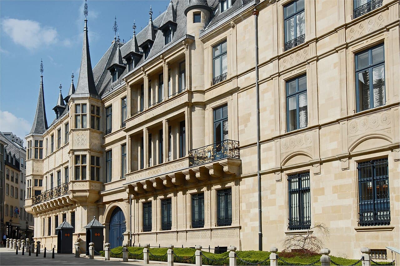
The old quarters and fortifications of the City of Luxembourg stand on a sandstone plateau cut by the deep, winding gorges of the Alzette and Pétrusse rivers. From the rocky spur called the Bock, a single castle grew over nine centuries into one of the strongest fortified sites in Europe, ringed by walls, bastions and roughly 23 kilometres of tunnels carved into the rock. Contemporaries called it the "Gibraltar of the North," and the French military engineer and statesman Lazare Carnot is often said to have rated it the strongest position on the continent after Gibraltar itself.
The fortress was never the work of one designer. It was rebuilt again and again by the powers that held it: the Holy Roman emperors, the House of Burgundy, the Spanish and Austrian Habsburgs, the kings of France, and finally Prussia. Each garrison added galleries, redoubts and gun positions until the whole plateau had become a honeycomb of military stonework. When the Second Treaty of London neutralised the country in 1867, most of that work was pulled down, yet enough survived to record every era of its construction.
In 1994 UNESCO inscribed the surviving ramparts, forts and casemates, together with the old town they defended, as the World Heritage Site "City of Luxembourg: its Old Quarters and Fortifications." The listing recognised the site as an outstanding example of a fortified European city and the largest surviving ensemble of underground fortifications of its kind.
The documented history of Luxembourg begins with a property exchange. On 7 April 963, Siegfried, a count in the Ardennes, obtained a rocky promontory above the Alzette from the Abbey of St Maximin at Trier; the deed, signed by Abbot Viker, traded Siegfried's estates at Feulen for the site. On the spur that later became known as the Bock, Siegfried built a castle called Lucilinburhuc, or "little fortress," and that name gradually turned into Luxembourg. Romans and Franks had already used the same promontory as a lookout and strongpoint, drawn by the steep cliffs and the river bends that shielded it on three sides.
A town gathered around and below the castle. In 1244 Countess Ermesinde granted the growing settlement a charter of freedoms, and the walls were pushed westward as churches, markets and workshops spread across the plateau. In the 14th and 15th centuries the county's own ruling house rose to the summit of European politics, giving the Holy Roman Empire several emperors and providing kings of Bohemia, so that the name Luxembourg carried far beyond the small territory on the Alzette. In 1354 the emperor Charles IV, himself of the Luxembourg line, raised the county to a duchy.
That prominence made the fortress a prize, and over the next four centuries it changed hands among the strongest powers in Europe. In 1443 Philip the Good of Burgundy seized the city and drew it into the Burgundian Netherlands; it passed to the Habsburgs in 1477 and, in the following century, to the Spanish branch of the family that governed the Low Countries from Brussels. Spanish engineers began the first casemates in 1644. In 1684 the armies of Louis XIV took the fortress after a siege, and Sébastien Le Prestre de Vauban, the foremost French military engineer of the age, rebuilt the defences into a modern bastioned system. The Treaty of Ryswick returned the city to Spanish rule in 1697, and Austrian control was confirmed in 1715, opening a long period of Habsburg administration directed from Vienna.
Under Austrian rule the underground works were extended further, including a major enlargement of the Bock casemates directed by General Neipperg in 1744. The armies of the French Republic besieged the fortress for some seven months in 1794 and 1795, and the territory was annexed by France in 1795. After the fall of Napoleon, the Congress of Vienna in 1815 raised Luxembourg to a grand duchy in personal union with the Netherlands, placed it inside the German Confederation, and installed a Prussian garrison of roughly 4,000 soldiers living among a civilian population of about 10,000, a division of the town that would last until 1867.
By the 19th century the fortress had reached its greatest extent. Its defences were arranged in three concentric rings and included around 24 forts, 15 in the inner works and 9 outer forts, linked by curtain walls, gates, bastions and redoubts that made use of the natural cliffs. Beneath and within this stonework ran the casemates, a system of galleries hewn into the sandstone that provided more than 40,000 square metres of bomb-proof space for guns, powder magazines, workshops, wells and barracks. At their fullest the tunnels ran to about 23 kilometres.
 Some seventeen kilometres of galleries were cut into the rock beneath the city, and they sheltered thousands of people during the Second World War. Photograph by LoKiLeCh, CC BY-SA 3.0, via Wikimedia Commons.
The casemates were what set Luxembourg apart. Begun by the Spanish in 1644 and extended under Vauban and then the Austrians, the galleries were carved on several levels so that defenders could fire from the cliff faces without being exposed. The Bock casemates, dug into the founding promontory, centre on a main passage about 110 metres long and up to 7 metres wide, with side branches fitted with roughly 25 cannon emplacements, 12 to the north and 13 to the south. In wartime these chambers, covering some 1,100 square metres, could hold up to 1,200 soldiers, drawing water from an internal well 47 metres deep. A second network, the Pétrusse casemates, was hollowed out under the southern valley and the ground now occupied by the Place de la Constitution.
The geography did much of the defensive work. On three sides the plateau falls away in sheer sandstone cliffs above the Alzette and the Pétrusse, so the only approach an attacker could use was the level ground to the west. That land front carried the heaviest works: successive lines of bastions, ravelins and outlying forts, laid out in the geometric manner Vauban had made standard, backed by the underground galleries that let defenders shift men and guns unseen. Inside the walls the fortress doubled as a garrison town, its barracks, magazines, bakeries and hospitals sharing the cramped plateau with a civilian population that lived under military rule and passed through fortified gates to reach the outside world.
The reputation that followed all this engineering was formidable. The nickname "Gibraltar of the North" reflected both the natural strength of the plateau and the density of the works layered onto it. The fortress was never stormed in a direct assault: when it changed hands, it did so through blockade and hunger or through negotiated surrender rather than a breach in the walls. That record, and the scale of the underground galleries, gave the fortress a standing in European military thinking out of all proportion to the size of the country it guarded.
The fortress met its end through diplomacy rather than battle. After the Austro-Prussian War of 1866, French Emperor Napoleon III tried to buy the grand duchy from William III of the Netherlands, who ruled it in personal union. Prussia, which still held the garrison, objected, and the dispute, known as the Luxembourg Crisis, brought the two powers close to war. The great powers settled it at a conference in London.
The Second Treaty of London, signed on 11 May 1867 by nine states, guaranteed the perpetual neutrality of the grand duchy, required the Prussian garrison to withdraw, and ordered the fortress dismantled. The Prussian troops marched out on 9 September 1867, and demolition began soon after. Tearing down the walls, gates and forts took about 16 years, running into the early 1880s, and cost in the region of 1.5 million gold francs.
The demolition reshaped the city. Cleared ramparts opened room for boulevards, parks and new districts, and the plateau that had been sealed behind walls became an ordinary, if dramatically sited, European capital. The Bock casemates were partly broken up, but they could not be fully destroyed without bringing down the streets above, so long stretches of the galleries survived. In the valleys below, the old quarters of Grund, Clausen and Pfaffenthal kept their historic street patterns, as did the Ville Haute on the heights, where the Grand Ducal Palace and the Notre-Dame Cathedral, begun by the Jesuits in 1613 and completed in 1621, still stand.
Freed from its walls, the city spread outward. The cleared glacis and esplanades that had once given the guns a clear field of fire became public gardens and tree-lined avenues, and building spread over the former military ground on the plateau and, from the 1960s, onto the Kirchberg heights. Luxembourg went on to become the capital of the world's only remaining sovereign grand duchy and, in the 20th century, a seat of several European institutions, among them the Court of Justice of the European Union. The old defences kept one more military role: during the Second World War the Bock casemates served as air-raid shelters said to have protected up to 35,000 people.
The 1994 inscription placed the old quarters and fortifications on the World Heritage List under cultural criterion (iv), as an outstanding example of a fortified European city that preserves major remains of its defences in an exceptional natural setting. Of the roughly 23 kilometres of galleries carved over the centuries, about 17 kilometres survive, described by UNESCO as the largest surviving ensemble of underground fortifications.
What survives is deliberately varied. Rather than a single monument, the property preserves a scatter of works representative of every period of the fortress: gates, forts, bastions, redoubts and long runs of casemates, set within the old street plan of the upper town and the valley quarters. That range is part of why the site was judged of outstanding universal value, because it lets a visitor read the whole development of European fortification across several centuries in one compact place.
The site is looked after by Luxembourg's national heritage authorities, which stabilise the crumbling sandstone, manage water damage in the tunnels and control how new building around the historic core is allowed to proceed. The pressures are real: a working capital continues to grow around a fragile historic core, traffic and weather wear at exposed stone, and the galleries need constant drainage and inspection to stay safe for the public. Restoration has recovered individual monuments as well: Fort Thüngen, one of the outer works spared in the 1867 demolition, was conserved and now houses the Dräi Eechelen museum of the fortress and the city's history. The Pétrusse casemates were closed for a long renovation and reopened to visitors in 2021 with new lighting and safer access. Because the fortifications are cut into living rock beneath an inhabited city, conservation is continuous rather than a single completed project.
The Bock casemates have been open to the public since 1933 and remain the most visited part of the fortress. They are entered from the Montée de Clausen near the site of Siegfried's original castle, generally open from spring through autumn, with an adult ticket of around 11 euros; the walk through the galleries takes roughly three quarters of an hour and involves stairs and low passages. The Pétrusse casemates are reached from the Place de la Constitution in the upper town.
Above ground, the Chemin de la Corniche, a rampart walk often called "Europe's most beautiful balcony," follows the old walls high over the Alzette valley and links the upper town to the Grund below. Fort Thüngen and the Dräi Eechelen museum sit on the Kirchberg plateau, and a glass lift at Pfaffenthal and a funicular connect the heights to the valley floor for those who would rather not climb. Notre-Dame Cathedral, the Grand Ducal Palace and the National Museum of History and Art are all within a short walk in the Ville Haute.
Luxembourg City is straightforward to reach. Findel Airport lies about 6 kilometres from the centre, and the railway station connects the city to Paris, Brussels and German cities by fast trains. Public transport across the whole country, including buses, trams and trains, has been free of charge since 1 March 2020, which makes moving between the plateau and the river districts simple. Streets in the old quarters are steep and cobbled, so sturdy shoes help; Luxembourgish, French and German are the official languages, and English is widely understood.
Some seventeen kilometres of galleries were cut into the rock beneath the city, and they sheltered thousands of people during the Second World War. Photograph by LoKiLeCh, CC BY-SA 3.0, via Wikimedia Commons.
The casemates were what set Luxembourg apart. Begun by the Spanish in 1644 and extended under Vauban and then the Austrians, the galleries were carved on several levels so that defenders could fire from the cliff faces without being exposed. The Bock casemates, dug into the founding promontory, centre on a main passage about 110 metres long and up to 7 metres wide, with side branches fitted with roughly 25 cannon emplacements, 12 to the north and 13 to the south. In wartime these chambers, covering some 1,100 square metres, could hold up to 1,200 soldiers, drawing water from an internal well 47 metres deep. A second network, the Pétrusse casemates, was hollowed out under the southern valley and the ground now occupied by the Place de la Constitution.
The geography did much of the defensive work. On three sides the plateau falls away in sheer sandstone cliffs above the Alzette and the Pétrusse, so the only approach an attacker could use was the level ground to the west. That land front carried the heaviest works: successive lines of bastions, ravelins and outlying forts, laid out in the geometric manner Vauban had made standard, backed by the underground galleries that let defenders shift men and guns unseen. Inside the walls the fortress doubled as a garrison town, its barracks, magazines, bakeries and hospitals sharing the cramped plateau with a civilian population that lived under military rule and passed through fortified gates to reach the outside world.
The reputation that followed all this engineering was formidable. The nickname "Gibraltar of the North" reflected both the natural strength of the plateau and the density of the works layered onto it. The fortress was never stormed in a direct assault: when it changed hands, it did so through blockade and hunger or through negotiated surrender rather than a breach in the walls. That record, and the scale of the underground galleries, gave the fortress a standing in European military thinking out of all proportion to the size of the country it guarded.
The fortress met its end through diplomacy rather than battle. After the Austro-Prussian War of 1866, French Emperor Napoleon III tried to buy the grand duchy from William III of the Netherlands, who ruled it in personal union. Prussia, which still held the garrison, objected, and the dispute, known as the Luxembourg Crisis, brought the two powers close to war. The great powers settled it at a conference in London.
The Second Treaty of London, signed on 11 May 1867 by nine states, guaranteed the perpetual neutrality of the grand duchy, required the Prussian garrison to withdraw, and ordered the fortress dismantled. The Prussian troops marched out on 9 September 1867, and demolition began soon after. Tearing down the walls, gates and forts took about 16 years, running into the early 1880s, and cost in the region of 1.5 million gold francs.
The demolition reshaped the city. Cleared ramparts opened room for boulevards, parks and new districts, and the plateau that had been sealed behind walls became an ordinary, if dramatically sited, European capital. The Bock casemates were partly broken up, but they could not be fully destroyed without bringing down the streets above, so long stretches of the galleries survived. In the valleys below, the old quarters of Grund, Clausen and Pfaffenthal kept their historic street patterns, as did the Ville Haute on the heights, where the Grand Ducal Palace and the Notre-Dame Cathedral, begun by the Jesuits in 1613 and completed in 1621, still stand.
Freed from its walls, the city spread outward. The cleared glacis and esplanades that had once given the guns a clear field of fire became public gardens and tree-lined avenues, and building spread over the former military ground on the plateau and, from the 1960s, onto the Kirchberg heights. Luxembourg went on to become the capital of the world's only remaining sovereign grand duchy and, in the 20th century, a seat of several European institutions, among them the Court of Justice of the European Union. The old defences kept one more military role: during the Second World War the Bock casemates served as air-raid shelters said to have protected up to 35,000 people.
The 1994 inscription placed the old quarters and fortifications on the World Heritage List under cultural criterion (iv), as an outstanding example of a fortified European city that preserves major remains of its defences in an exceptional natural setting. Of the roughly 23 kilometres of galleries carved over the centuries, about 17 kilometres survive, described by UNESCO as the largest surviving ensemble of underground fortifications.
What survives is deliberately varied. Rather than a single monument, the property preserves a scatter of works representative of every period of the fortress: gates, forts, bastions, redoubts and long runs of casemates, set within the old street plan of the upper town and the valley quarters. That range is part of why the site was judged of outstanding universal value, because it lets a visitor read the whole development of European fortification across several centuries in one compact place.
The site is looked after by Luxembourg's national heritage authorities, which stabilise the crumbling sandstone, manage water damage in the tunnels and control how new building around the historic core is allowed to proceed. The pressures are real: a working capital continues to grow around a fragile historic core, traffic and weather wear at exposed stone, and the galleries need constant drainage and inspection to stay safe for the public. Restoration has recovered individual monuments as well: Fort Thüngen, one of the outer works spared in the 1867 demolition, was conserved and now houses the Dräi Eechelen museum of the fortress and the city's history. The Pétrusse casemates were closed for a long renovation and reopened to visitors in 2021 with new lighting and safer access. Because the fortifications are cut into living rock beneath an inhabited city, conservation is continuous rather than a single completed project.
The Bock casemates have been open to the public since 1933 and remain the most visited part of the fortress. They are entered from the Montée de Clausen near the site of Siegfried's original castle, generally open from spring through autumn, with an adult ticket of around 11 euros; the walk through the galleries takes roughly three quarters of an hour and involves stairs and low passages. The Pétrusse casemates are reached from the Place de la Constitution in the upper town.
Above ground, the Chemin de la Corniche, a rampart walk often called "Europe's most beautiful balcony," follows the old walls high over the Alzette valley and links the upper town to the Grund below. Fort Thüngen and the Dräi Eechelen museum sit on the Kirchberg plateau, and a glass lift at Pfaffenthal and a funicular connect the heights to the valley floor for those who would rather not climb. Notre-Dame Cathedral, the Grand Ducal Palace and the National Museum of History and Art are all within a short walk in the Ville Haute.
Luxembourg City is straightforward to reach. Findel Airport lies about 6 kilometres from the centre, and the railway station connects the city to Paris, Brussels and German cities by fast trains. Public transport across the whole country, including buses, trams and trains, has been free of charge since 1 March 2020, which makes moving between the plateau and the river districts simple. Streets in the old quarters are steep and cobbled, so sturdy shoes help; Luxembourgish, French and German are the official languages, and English is widely understood.
History
The fortress and the casemates
Dismantling and the modern city
Preservation
Visiting
References and resources
- UNESCO World Heritage Centre: City of Luxembourg, its Old Quarters and Fortifications (site 699)
- Wikipedia: Fortress of Luxembourg
- Wikipedia: Bock (Luxembourg)
- Wikipedia: Luxembourg City
- Encyclopaedia Britannica: Luxembourg (national capital)
- Wikipedia: Treaty of London (1867)
- Visit Luxembourg City: Bock Casemates
- Visit Luxembourg City: the underground and the casemates