Heritage · Landmark
Petra: History, Attractions & Visitor Guide
Petra is the Nabataean capital in southern Jordan, whose monuments were cut facade by facade directly into cliffs of rose and ochre sandstone.Written to last.
By Confinity Heritage Editorial · Updated 2026-07-20 · 7-minute readQuiet tools, kept out of the way.
Petra is an ancient city in southern Jordan whose most famous monuments were cut, facade by facade, directly into cliffs of rose and ochre sandstone. For several centuries around the turn of the first millennium it was the capital of the Nabataeans, a formerly nomadic Arab people who grew wealthy by controlling the desert caravan routes that carried frankincense, myrrh and spices between southern Arabia, the Mediterranean and the East.
The site lies in a mountain basin near the edge of the Wadi Araba rift valley, at roughly 810 metres above sea level in Jordan's Ma'an Governorate. Its familiar name comes from the Greek word for rock; the Nabataeans themselves knew the place as Raqmu. A UNESCO World Heritage Site since 1985 and one of the New7Wonders of the World since 2007, Petra is Jordan's most visited attraction, drawing more than a million people in a strong year.
Its signature monument, Al-Khazneh (the Treasury), stands at the end of a long, shadowed gorge called the Siq, its columned facade appearing without warning to anyone who walks out of the canyon. That reveal has made Petra one of the most photographed ruins on Earth, even though archaeologists estimate that only a small share of the buried city has ever been dug.
People lived in this corner of the highlands long before the Nabataeans. Pre-Pottery Neolithic settlement at nearby Beidha reaches back to roughly the 7th millennium BC, and the surrounding region appears in Iron Age records as part of ancient Edom. The Nabataeans enter the historical record around the 4th century BC as a mobile Arab people, and by about the 2nd century BC they had made Petra the seat of their kingdom.
Their fortune rested on trade. Petra sat at a junction of routes linking the incense-growing regions of southern Arabia with markets in Gaza, Damascus and beyond, and the Nabataeans taxed, guided and provisioned the caravans that passed through. That commerce paid for the carved tombs, temples and civic buildings that fill the basin. At its height in the 1st century AD the city may have held around 20,000 inhabitants.
Rome absorbed the kingdom in AD 106, when the emperor Trajan annexed Nabataea and reorganised it as the province of Arabia Petraea. The provincial capital moved north to Bostra, in present-day Syria, yet Petra stayed prosperous for a time and gained Roman touches, including a colonnaded main street. Over the following centuries its importance faded as long-distance trade shifted increasingly to sea lanes through the Red Sea.
Earthquakes then compounded the decline. A powerful quake in AD 363 toppled many buildings and damaged the water network the city depended on. Petra was not abandoned outright: in the Byzantine period it became a Christian bishopric, and churches were raised over and beside older structures. One of them preserved a cache of carbonised papyrus scrolls, documents whose survival shows that daily life and property dealings continued into the 6th century. A second major earthquake, in AD 551, is often blamed for the final blow, though the scroll evidence complicates any single tidy ending. By the time of the Islamic conquests in the 7th century, Petra had shrunk to a settlement of little regional weight. Crusaders built two small forts nearby in the 12th century, after which the city slipped out of European knowledge for roughly six hundred years.
Petra's monuments fall into two broad kinds: structures carved into the living rock, and free-standing buildings assembled from cut blocks. The carved works are what most visitors remember. Craftsmen worked from the top of a cliff downward, shaping columns, pediments and doorways out of the sandstone rather than adding them, which meant a facade could not be corrected once cutting began.
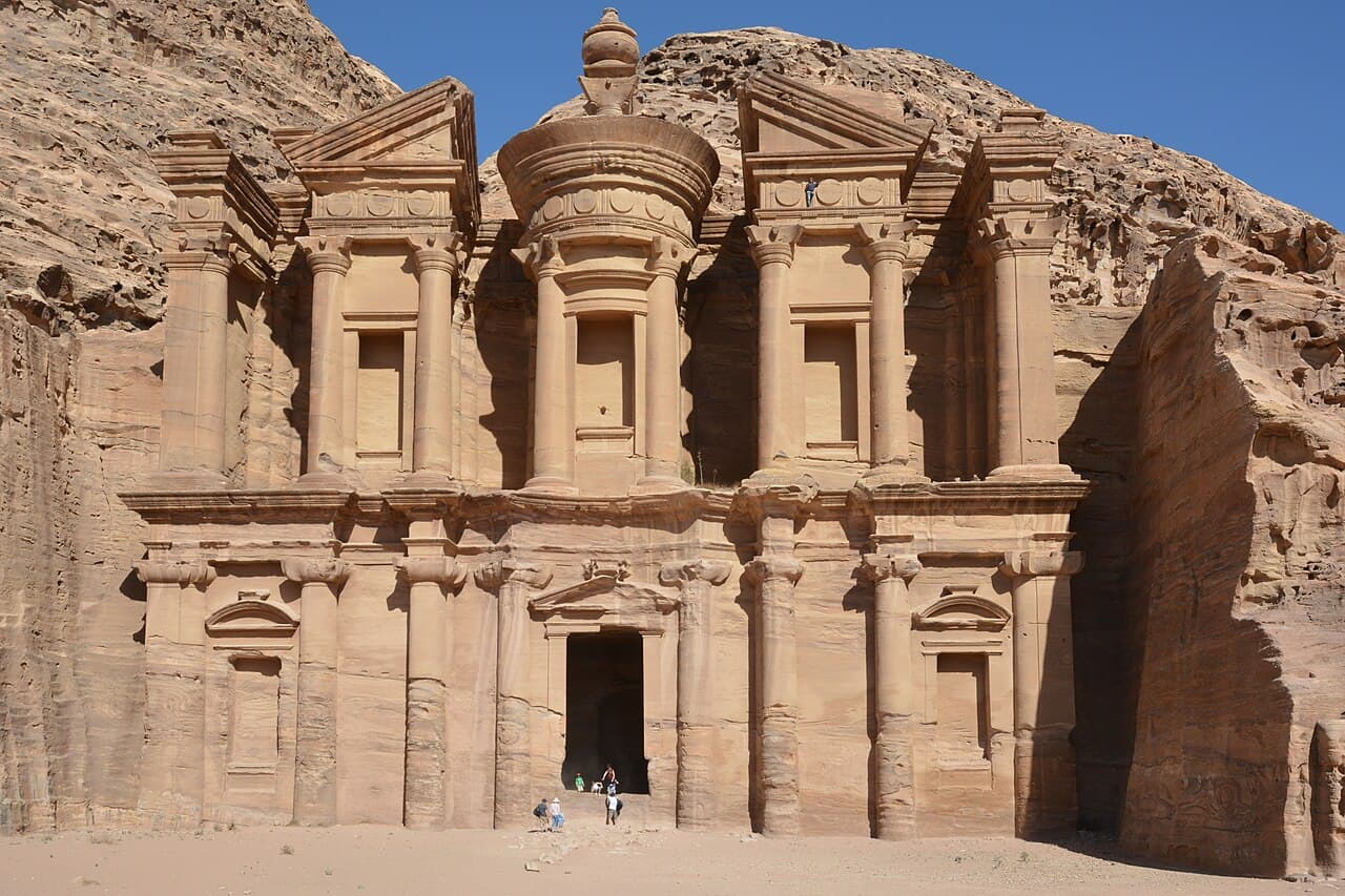
 Al-Khazneh is cut into the cliff rather than built against it, worked from the top down so no scaffolding was needed. Photograph by Vyacheslav Argenberg, CC BY 4.0, via Wikimedia Commons.
The Treasury, or Al-Khazneh, is the best-known example. Its Hellenistic front stands some 37 metres tall and roughly 24 metres wide, decorated with columns, a broken pediment and a central rotunda. Despite the name given to it by later Bedouin, who imagined treasure hidden in the stone urn at its top, most scholars read Al-Khazneh as a royal mausoleum, probably built for the Nabataean king Aretas IV in the early 1st century AD. Larger still is Ad-Deir, the Monastery, which measures about 45 metres tall and 50 metres wide and sits at the top of a long rock-cut stairway above the city. It likely served as a Nabataean temple or ceremonial hall, and a carved cross from a later period is the source of its Christian nickname.
Between and around these set pieces are hundreds of tombs and civic works. The Street of Facades lines the approach with rows of carved tomb fronts, and the cliffside known as the royal tombs holds the Urn, Palace, Corinthian and Silk tombs. A theatre carved into the hillside could seat something on the order of 8,500 spectators; the Nabataeans cut it and the Romans later enlarged it. Away from the carved cliffs stand the free-standing ruins, among them the colonnaded street and Qasr al-Bint, one of the few masonry temples still partly upright. High above the basin, reached by cut staircases, are open-air sanctuaries such as the high place of sacrifice on Jebel al-Madbah.
None of this could have supported a desert city without water engineering, and the Nabataean handling of water is as impressive as any facade. The builders combined dams, cisterns, reservoirs, rock-cut channels and ceramic pipes into a network that captured the region's brief, violent seasonal rains and stored them through the dry months. UNESCO's citation for the site singles out these channels, tunnels and diversion dams, which fed a wide system of cisterns and reservoirs, as central to Petra's outstanding value.
The most striking piece of that engineering guards the entrance itself. The Siq, the gorge that leads into the city, is a natural cleft over 1.2 kilometres long and in places only 3 to 4 metres wide. Flash floods pouring down the Wadi Musa could turn it into a death trap, so the Nabataeans built a dam across the wadi and cut a tunnel roughly 90 metres long to divert the floodwater away from the Siq into an adjacent valley. Terracotta pipes and a rock-cut channel ran along the gorge walls to bring clean drinking water in at the same time. The danger was never theoretical: a flash flood in 1963 killed a group of tourists in the Siq, and the ancient diversion dam was rebuilt afterward, and again in the early 1990s, to protect visitors much as it once protected the city.
Petra matters as more than a set of beautiful ruins. It is the fullest surviving expression of Nabataean civilisation, a society that blended Arab roots with influences drawn from the Hellenistic Greek world, Egypt, Mesopotamia and Rome. That mixture is visible in the architecture, where classical columns and pediments sit atop tomb forms and crow-step motifs that belong to a distinct local tradition. The Nabataeans also wrote in a cursive Aramaic script of their own, one that scholars regard as an important ancestor of the later Arabic script.
UNESCO inscribed the site under three of its cultural criteria, recognising both a unique artistic achievement and exceptional testimony to a lost civilisation. The citation describes the fusion of Hellenistic facades with Nabataean rock-cut tombs, among them the Treasury, the Urn Tomb, the Palace Tomb, the Corinthian Tomb and the Monastery, as an outstanding architectural ensemble of the first centuries BC and AD.
The city has also lodged itself firmly in the modern imagination. The Victorian traveller John William Burgon famously called it "a rose-red city half as old as time," a line from his 1845 poem that still shapes how Petra is described. In 1989 the Treasury's facade stood in for the temple housing the Holy Grail in Indiana Jones and the Last Crusade, an appearance that sent tourism climbing. In 2007 a global public poll organised by the New7Wonders Foundation named Petra one of the New7Wonders of the World, cementing its place alongside the Colosseum and the Great Wall in popular lists of must-see monuments.
Europe forgot Petra after the Crusades, and the city stayed known mainly to local Bedouin until the Swiss explorer Johann Ludwig Burckhardt reached it in 1812. Travelling under the assumed name Sheikh Ibrahim ibn Abdallah and posing as a Muslim pilgrim, Burckhardt persuaded a guide to take him to the reputed tomb of Aaron near the ruins, and in doing so became the first outsider in centuries to record the site for the Western world. His account drew a stream of nineteenth-century artists, surveyors and scholars, and systematic archaeology followed in the twentieth century.
Much of Petra is still underground. Researchers commonly estimate that only around 15 percent of the city has been excavated, and satellite surveys have since traced large buried structures beneath the sand, including a monumental platform overlooked by earlier expeditions. Excavation and conservation have been led over the years by Jordanian authorities working with foreign partners, including projects run by the American Center of Research (ACOR) at the Temple of the Winged Lions and the Byzantine church, and long-running facade-conservation work with German teams.
Preservation is a constant struggle against both nature and popularity. The sandstone weathers under wind, rain, salt and temperature swings, and the soft rock erodes wherever feet, hands and hooves pass over it. Flash floods remain a seasonal hazard, and heavy visitor traffic concentrates wear on the most famous paths. Jordanian bodies such as the Petra Development and Tourism Region Authority and the Petra National Trust manage the archaeological park and pursue plans to spread visitors more evenly and to steady the most fragile monuments.
Petra sits beside the town of Wadi Musa, about a three-hour drive south of Amman and a similar distance north of the Red Sea port of Aqaba along the Desert Highway or the older King's Highway. Most visitors reach it by car, tour coach or the tourist minibus services that run from Amman and Aqaba, and Wadi Musa offers the full range of hotels near the gate.
Entry is through the modern visitor centre, from which a walking path leads down past the first tombs to the mouth of the Siq. A single-day adult ticket for foreign visitors costs around 50 Jordanian dinars, with two- and three-day options available; travellers can also fold admission into the Jordan Pass, which bundles the entry fee with the tourist visa and is usually the better value for anyone spending several days in the country. The park generally opens in the early morning and closes around sunset, with hours shifting by season.
The classic route runs roughly 2 kilometres through the Siq to the sudden view of the Treasury, then on past the Street of Facades, the theatre and the royal tombs to the colonnaded street and Qasr al-Bint at the heart of the city. From there a stairway of many hundreds of steps climbs to the Monastery, and other trails lead up to the high place of sacrifice or to viewpoints above the Treasury. Seeing the main sites comfortably takes the better part of a day, and the site rewards more time. On select evenings the Petra by Night event lights the Siq and the Treasury forecourt with candles for a slower, quieter walk.
Early morning and late afternoon bring softer light, cooler temperatures and thinner crowds, and the shoulder seasons of spring and autumn are the most comfortable months to walk the exposed trails. Visitors help preserve the site by keeping to marked paths, leaving the carved facades untouched, and carrying enough water for a long day on foot. Petra also works well as the anchor of a wider trip: the smaller rock-cut site of Little Petra (Siq al-Barid) lies a short drive north, and the desert landscapes of Wadi Rum and the beaches of Aqaba are both within easy reach to the south.
Al-Khazneh is cut into the cliff rather than built against it, worked from the top down so no scaffolding was needed. Photograph by Vyacheslav Argenberg, CC BY 4.0, via Wikimedia Commons.
The Treasury, or Al-Khazneh, is the best-known example. Its Hellenistic front stands some 37 metres tall and roughly 24 metres wide, decorated with columns, a broken pediment and a central rotunda. Despite the name given to it by later Bedouin, who imagined treasure hidden in the stone urn at its top, most scholars read Al-Khazneh as a royal mausoleum, probably built for the Nabataean king Aretas IV in the early 1st century AD. Larger still is Ad-Deir, the Monastery, which measures about 45 metres tall and 50 metres wide and sits at the top of a long rock-cut stairway above the city. It likely served as a Nabataean temple or ceremonial hall, and a carved cross from a later period is the source of its Christian nickname.
Between and around these set pieces are hundreds of tombs and civic works. The Street of Facades lines the approach with rows of carved tomb fronts, and the cliffside known as the royal tombs holds the Urn, Palace, Corinthian and Silk tombs. A theatre carved into the hillside could seat something on the order of 8,500 spectators; the Nabataeans cut it and the Romans later enlarged it. Away from the carved cliffs stand the free-standing ruins, among them the colonnaded street and Qasr al-Bint, one of the few masonry temples still partly upright. High above the basin, reached by cut staircases, are open-air sanctuaries such as the high place of sacrifice on Jebel al-Madbah.
None of this could have supported a desert city without water engineering, and the Nabataean handling of water is as impressive as any facade. The builders combined dams, cisterns, reservoirs, rock-cut channels and ceramic pipes into a network that captured the region's brief, violent seasonal rains and stored them through the dry months. UNESCO's citation for the site singles out these channels, tunnels and diversion dams, which fed a wide system of cisterns and reservoirs, as central to Petra's outstanding value.
The most striking piece of that engineering guards the entrance itself. The Siq, the gorge that leads into the city, is a natural cleft over 1.2 kilometres long and in places only 3 to 4 metres wide. Flash floods pouring down the Wadi Musa could turn it into a death trap, so the Nabataeans built a dam across the wadi and cut a tunnel roughly 90 metres long to divert the floodwater away from the Siq into an adjacent valley. Terracotta pipes and a rock-cut channel ran along the gorge walls to bring clean drinking water in at the same time. The danger was never theoretical: a flash flood in 1963 killed a group of tourists in the Siq, and the ancient diversion dam was rebuilt afterward, and again in the early 1990s, to protect visitors much as it once protected the city.
Petra matters as more than a set of beautiful ruins. It is the fullest surviving expression of Nabataean civilisation, a society that blended Arab roots with influences drawn from the Hellenistic Greek world, Egypt, Mesopotamia and Rome. That mixture is visible in the architecture, where classical columns and pediments sit atop tomb forms and crow-step motifs that belong to a distinct local tradition. The Nabataeans also wrote in a cursive Aramaic script of their own, one that scholars regard as an important ancestor of the later Arabic script.
UNESCO inscribed the site under three of its cultural criteria, recognising both a unique artistic achievement and exceptional testimony to a lost civilisation. The citation describes the fusion of Hellenistic facades with Nabataean rock-cut tombs, among them the Treasury, the Urn Tomb, the Palace Tomb, the Corinthian Tomb and the Monastery, as an outstanding architectural ensemble of the first centuries BC and AD.
The city has also lodged itself firmly in the modern imagination. The Victorian traveller John William Burgon famously called it "a rose-red city half as old as time," a line from his 1845 poem that still shapes how Petra is described. In 1989 the Treasury's facade stood in for the temple housing the Holy Grail in Indiana Jones and the Last Crusade, an appearance that sent tourism climbing. In 2007 a global public poll organised by the New7Wonders Foundation named Petra one of the New7Wonders of the World, cementing its place alongside the Colosseum and the Great Wall in popular lists of must-see monuments.
Europe forgot Petra after the Crusades, and the city stayed known mainly to local Bedouin until the Swiss explorer Johann Ludwig Burckhardt reached it in 1812. Travelling under the assumed name Sheikh Ibrahim ibn Abdallah and posing as a Muslim pilgrim, Burckhardt persuaded a guide to take him to the reputed tomb of Aaron near the ruins, and in doing so became the first outsider in centuries to record the site for the Western world. His account drew a stream of nineteenth-century artists, surveyors and scholars, and systematic archaeology followed in the twentieth century.
Much of Petra is still underground. Researchers commonly estimate that only around 15 percent of the city has been excavated, and satellite surveys have since traced large buried structures beneath the sand, including a monumental platform overlooked by earlier expeditions. Excavation and conservation have been led over the years by Jordanian authorities working with foreign partners, including projects run by the American Center of Research (ACOR) at the Temple of the Winged Lions and the Byzantine church, and long-running facade-conservation work with German teams.
Preservation is a constant struggle against both nature and popularity. The sandstone weathers under wind, rain, salt and temperature swings, and the soft rock erodes wherever feet, hands and hooves pass over it. Flash floods remain a seasonal hazard, and heavy visitor traffic concentrates wear on the most famous paths. Jordanian bodies such as the Petra Development and Tourism Region Authority and the Petra National Trust manage the archaeological park and pursue plans to spread visitors more evenly and to steady the most fragile monuments.
Petra sits beside the town of Wadi Musa, about a three-hour drive south of Amman and a similar distance north of the Red Sea port of Aqaba along the Desert Highway or the older King's Highway. Most visitors reach it by car, tour coach or the tourist minibus services that run from Amman and Aqaba, and Wadi Musa offers the full range of hotels near the gate.
Entry is through the modern visitor centre, from which a walking path leads down past the first tombs to the mouth of the Siq. A single-day adult ticket for foreign visitors costs around 50 Jordanian dinars, with two- and three-day options available; travellers can also fold admission into the Jordan Pass, which bundles the entry fee with the tourist visa and is usually the better value for anyone spending several days in the country. The park generally opens in the early morning and closes around sunset, with hours shifting by season.
The classic route runs roughly 2 kilometres through the Siq to the sudden view of the Treasury, then on past the Street of Facades, the theatre and the royal tombs to the colonnaded street and Qasr al-Bint at the heart of the city. From there a stairway of many hundreds of steps climbs to the Monastery, and other trails lead up to the high place of sacrifice or to viewpoints above the Treasury. Seeing the main sites comfortably takes the better part of a day, and the site rewards more time. On select evenings the Petra by Night event lights the Siq and the Treasury forecourt with candles for a slower, quieter walk.
Early morning and late afternoon bring softer light, cooler temperatures and thinner crowds, and the shoulder seasons of spring and autumn are the most comfortable months to walk the exposed trails. Visitors help preserve the site by keeping to marked paths, leaving the carved facades untouched, and carrying enough water for a long day on foot. Petra also works well as the anchor of a wider trip: the smaller rock-cut site of Little Petra (Siq al-Barid) lies a short drive north, and the desert landscapes of Wadi Rum and the beaches of Aqaba are both within easy reach to the south.
History
The rock-cut city and its water system
Cultural significance
Rediscovery and preservation
Visiting
References and resources
- UNESCO World Heritage Centre: Petra (inscription 326). Official listing, criteria and statement of outstanding universal value.
- Encyclopaedia Britannica: Petra. Overview of the ancient city and Nabataean kingdom.
- Britannica: Arabia (Roman province). The Roman annexation of Nabataea in AD 105–106.
- Wikipedia: Petra. Detailed history, architecture and figures with citations.
- Wikipedia: Nabataeans. Background on the people who built Petra.
- National Geographic: The lost city of Petra. Reporting on excavation and still-buried remains.
- Smithsonian Magazine: Reconstructing Petra. The Byzantine church, papyrus scrolls and later occupation.
- House of Switzerland: Sheikh Ibrahim, the Swiss who discovered Petra. Burckhardt's 1812 rediscovery.
- Visit Petra (official tourism site). Tickets, opening hours and practical planning.